Wednesday, May 13, 2015

The Double-Duty Finger Guild


A program to train and employ the blind at the Crocker-Wheeler factory in East Orange was started by company president Schuyler Wheeler in 1917 at the NE corner of N 15th Street and Park Avenue.


Friday, May 8, 2015

Ruth Lindsay, Founder of the Candy Stripers

In 1944 teacher Ruth Lindsay started the volunteer organization known as the Candy Stripers at Vernon L Davey Junior High School.  By the late 1950's, Miss Lindsay was a teacher at East Orange High School and had moved the program there.

                          Above: Miss Ruth Lindsay in the 1944 Vernon L Davey yearbook

                              The girls volunteered at East Orange General Hospital.

                              Below: from the 1958 East Orange High School yearbook

Friday, April 24, 2015

Debating Whether East Orange Should Accept a Carnegie Library

From the New York Times January 26, 1900:


But the offer from Andrew Carnegie was accepted and the East Orange Carnegie Library below opened in January 1903.


Re. the Orange/Stickler Library, mentioned in the article, from a history of Essex County: "The laying of the corner stone of the present library [Stickler library] took place at Essex Avenue and Main Street, June 25, 1900."

1916 East Orange High Yearbook

Photos from the 1916 Syllabus, the East Orange High School yeabook; more from the yearbook here.


                                                      Girls Physical Training Association

                                                                            Football Team

                                                                 Basketball Team

                                                                  Cross Country Team

                                                                    Baseball Team

                                                                       News Staff


More links to the 1916 yearbook here.

Saturday, April 18, 2015

The Lincoln-Mayflower Building


Above and below: C1575 9/4/1913


One of the most significant landmarks in the Grove Street Lackawanna station neighborhood for 60 years was the building that, in its final years, was called the Lincoln-Mayflower Storage Building. It was the tallest structure in the area and was on a high piece of ground. It was built about 1912 and was knocked down in the early 1970's during construction of I-280.

                                          Above: 9/4/1913 soon after the building was completed

The building was originally operated as "J Dietrich Inc Fireproof Storage Warehouse"

 Below: detail from C2743, 6/17/1915

                                                           
Above: C3017, 10/21/1915

Below: C3018 10/21/1915

                    Above X1841: By 3/15/1921 it was called the Lincoln Storage Warehouse

                                                              Below X2361, 1/26/1922
                                                       
                                                           Above: detail from X2364 1/26/1922

                                                          Below: detail from X2639 8/22/1922


                                                             Below X3385, 4/4/1924


 Above X2366 looking ENE from roof of Lincoln Storage Warehouse, Sacred Heart Cathedral in center distance, one mile away 1/26/1922

Below X2367 looking W from roof of Lincoln Storage Warehouse, The Grove Apartments in foreground, Commonwealth Building at Arlington Ave and Main St in distant center  1/26/1922

Thursday, March 5, 2015

The Grove Street Lackawanna Station Area During and Following the Elevation Project, 1921-1924

Photos courtesy of Steamtown NHS (National Historic Site) Archives


Above 8/1922

                                         Above X2361: Looking WSW across Greenwood Avenue in 1922; tall building is Lincoln (later Lincoln-Mayflower) Storage building; Firehouse #2 with training tower in left center; top of Grove Street Congregational Church is at far left, 1/26/1922

Below X2363: the rear of homes on the south side of Eaton Place near its intersection with 14th Street; this is the inclined section of track that leaves the depression or "cut" at Roseville to become the elevated part going through the Oranges, 1/26/1922


Above X2368: looking north across the railroad  along North Grove Street; the railroad was being elevated about 10 feet and then Grove Street was lowered to create an underpass, Grove Court Apts. on left, 1/26/1922

             Below X2369: looking east along the railroad from North Maple Street bridge  toward the intersection with Grove Street, 1/26/1922

Above X2370: looking west from North Maple Street bridge, Commonwealth Building (Main Street and Arlington Avenue) in background, 1922

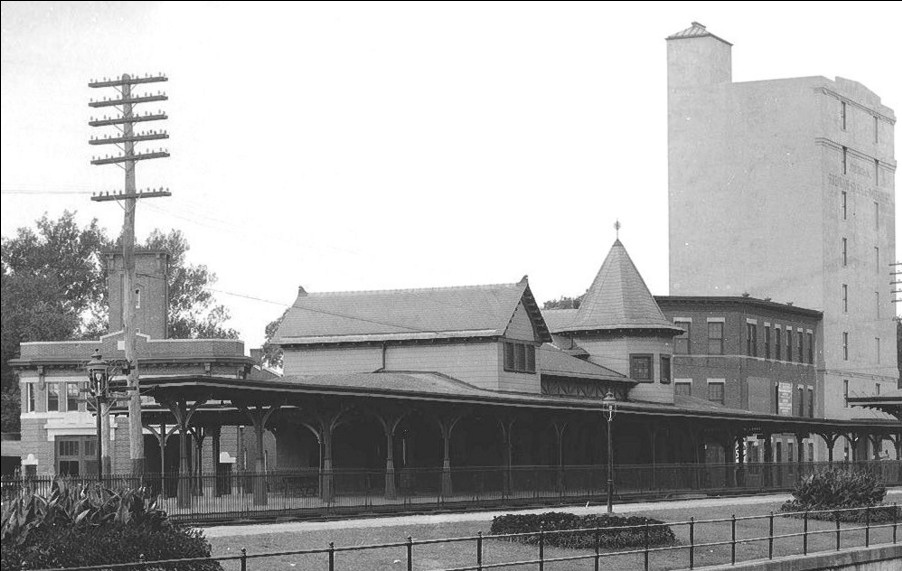
Above X3385: looking east from North Grove Street, tall Lincoln (later Lincoln-Mayflower) Storage building on right, Grove Street Lackawanna station in center, Greenwood Apts (NE corner of Eaton Place and 19th Street/Greenwood Avenue) in distant left, 1924 

Below: looking east, Grove Street station in foreground, Sacred Heart Cathedral in left background, 1924


Above X3386: looking east from pedestrian bridge that replaced the North Maple Street bridge after elevation, 1924


Above: looking west across North Hollywood Avenue, Grove Street station on right, Grove Court Apartments (fronting on Grove Street) in background

Below X2366: looking ENE, Grove Street station at bottom, Sacred Heart Cathedral in center distance one mile away 1/26/1922

                              Below, 3/1921: looking NW across Eaton Place, The Oval to the left

                     
Above (X1825) and below (X1826) east side of Greenwood Avenue between Eaton Place and the RR 3/12/1921


        Above (X1836) and below (X1837) east side of Greenwood Ave near Main St 3/12/1921

     Above (X1845): Grove Court Apartments, west side of Grove Street between the RR and Main Street 4/13/1921

                        Above (X1839): The Grove Apartments, west side of North Grove Street at RR

                                                                    Above (X1838): looking ESE toward east side of Greenwood Ave a few feet south of the RR 3/12/1921

                                                                    Below (X1831): looking SW at the north side of Hollywood Place; Grove St station is to photographer's right

 Above X1820: looking east from Greenwood Ave, back of homes on Eaton Place to the left, Libman building on N 15th St in center ,distance, 3/11/1921
             Below X1821: looking NE across RR toward houses at the intersection of Eaton Place and N. 16th St 3/11/1921

                                                Above X1822: 3/11/1921

        Below X1828: looking NW at the SE corner of Greenwood Avenue and Eaton Place 3/12/1921

                       Above X1834: looking SW at the intersection of Main St and Greenwood Ave, 3/12/1921

                              Below X1835 the SW corner of Main St and Greenwood Ave, 3/12/1921

Above X1832 and below X1833: looking SW toward houses on west side of Greenwood Ave between RR/Hollywood Place and Main St 3/12/1921

Above X1840, 3/1921: 1st house next (south side) to RR, east side of Grove Street
Below, X1841, 3/1921: 2nd house from (south side) to RR, east side of Grove Street

Above X1842, 3/1921: 3rd house from (south side)  RR, east side of Grove Street
Below X1843, 3/1921: 4th house from (south side)  RR, east side of Grove Street

Above X1844, 3/1921: west side of Grove St between the RR and Main St